Sailing can be a humbling experience. It’s even more humbling when your first major misadventure involves running aground… on your first solo outing as skipper… and with a boat you don’t own.
Turns out, running aground in Apalachee Bay, where I sail, is quite common. These mishaps are one reason why almost everyone has an annual membership to SeaTow or TowBoatUS. (Fair warning: out-of-pocket cost for these services will run about $350 per hour.)
While I have been sailing small boats for a while, my experience has largely been on small inland lakes. Now that I live in Tallahassee, I felt it was time to up my game. So, I joined the Apalachee Bay Yacht Club.
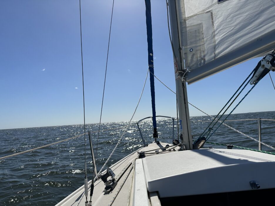
A beautiful day for a sail
I was qualified by the fleet manager to sail the ABYC club boat, a 22’ Capri daysailer named “Maxie”, on November 12, 2022. My first sail as a solo captain was on Saturday, February 4, 2023.
We – I was joined by two intrepid friends from Florida State University – set out a little after noon on a beautiful afternoon. A minor mishap delayed our timely departure when I failed to ensure the outboard engine’s propeller was fully lowered into the water and firmly locked in. That was an embarrassing but easy fix.

Overall, however, we were able to navigate out of a tricky channel. In fact, the channel out to open water from ABYC is one of the features new skippers must be qualified to handle before they receive permission to take club boats out.
The first part of the sail was quite amazing – everything I hoped for as a sailor. Winds were strong and steady on a blue-sky day. The trip was peaceful, and we could simply soak up the time on the water as we clipped along toward the Gulf of Mexico.
Return trip… not so easy
After sailing about 4 miles south, near the mouth of the bay, we turned around for our return journey. One mile later – and three miles from the yacht club – we were firmly aground on a shoal quite literally in the middle of the Bay.
To add insult to injury, at one point a large wave lifted our boat and brought our stern down so hard that the rudder broke off on its hinges (breaking gudgeons and pintles)!
We were aground and rudderless.

Still, I knew if we could get off the shoal we could motor our way back to the yacht club. We had plenty of gas, and the Maxie can hold a stable course with its keel given its draft of about 4 feet.
We tried a variety of tricks to lift us off the sandbar using the sails, outboard motor, poling with an oar, and even getting into the water to push us toward deeper water.
SeaTow to the rescue
After about 90 minutes, with sunset not too far off, I decided SeaTow was our best option. This was a good decision. We learned quite quickly that even the SeaTow boat with two large marine engines had a bit of trouble pulling us completely free.
We were soon in clear water, only to find that our fuel line for the outboard engine had sprung a major leak. Despite the fuel levels, given the amount of gasoline leaking into the bay, we were unlikely to make it back to the slip under our own power. I had SeaTow take us back to the Yacht Club.
Maxie was safely back in its slip around 6 pm, just in time for the ABYC’s monthly meeting to start.
Needless to say, I provided the entertainment for many as SeaTow brought us back to the slip.
The ABC’s of running aground
So, what happened? Quite simply, I made a rookie mistake which led to a navigation error.
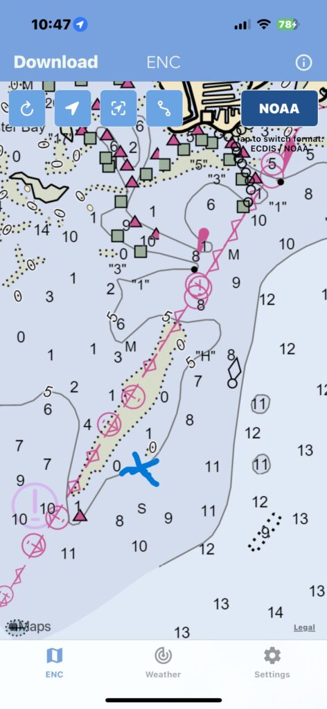
The shoal, in fact, is marked on the navigational charts as the first figure shows. As the figure above shows, X literally marks the spot where we ran aground.
The beige area represents the contours of the shoal, which is above water at low tide. We were sailing near high tide. Thus, the sandbar was under water.
The numbers in the blue area reflect the water depth at the lowest point during low tide according to the chart. We ran aground at a place marked as 0 feet at low tide. As a practical matter, however, the depth was closer to three feet given the tides that day. But we are also on a falling tide. So the longer we waited the more difficult dislodging the boat would become.
On closer inspection, we could see the waves breaking over the shallow water. The relatively high winds, however, had many waves break.
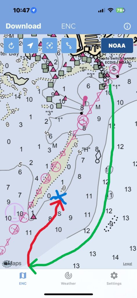
The green line and arrow in Figure 2 shows our course leaving the marked channels near Shell Point (behind which ABYC is located). Sailing due south allowed us to make excellent time in the deeper part of the channel.

The red arrow reflects our return journey, which led us directly onto the shoal.
Why did we follow the red arrow and not the green arrow?
Two simple, correctable mistakes
My mistakes were simple and two fold.
First, I failed to adequately estimate the “drift” from Easterly winds. A common navigational error is not to account for how the wind will push a boat in the direction of the wind. I needed to be steering into the wind a bit to ensure we stayed on a straight line.
My inexperience sailing in the bay, inability to adequately gauge the distance of key landmarks, and my lack of understanding of water depths and locations kept me from making the right calculations to stay in the deep water of the channel.
Second, and perhaps most importantly, I did not regularly check the position of our boat using my GPS. I have both a stand alone GPS device and a GPS tracker on my cell phone. If I had simply tracked our progress, I would have seen where our boat was, and I could have made the necessary adjustments.
These two simple failures led to our boat going aground. Lessons learned.
Overall no worse for the wear
Overall, however, I left the experience with a lot more confidence in my boat handling skills. At least with a daysailer like the Maxie, I can get the boat where I want to get it. I am learning, and far from an expert. But my sailing foundations are good thanks in no small part to all that experience gained sailing dinghies on inland lakes.
As for my navigational skills? Those still need a lot of work.
I needed a few days to recover, but I am ready to get back on the water again as soon as possible.
