The Apalachee Bay Yacht Club is located in the middle of one of several canals built to provide access to Apalachee Bay for homeowners and vacationers at Shell Point, Florida. The yacht club itself is located on Harbour Point Drive, which is the canal furthest from the Bay. While this provides great protection from weather and storms, the disadvantage is a rather lengthy (about 1 mile) journey to the Bay itself.
This navigation, however, is more than a little challenging. Indeed, getting to the Bay might be the most taxing part of sailing on Apalachee Bay!
The Bay requires sailing around the notorious “doughnut,” a shoal that has become the bane of many sailors. At low tide, the middle of the channel may be less than 3 feet. Larger sailboats have drafts of 4 and 5 feet, which makes exiting and returning to the yacht club quite literally impossible at low tide. Fortunately, high tides provide passable passage.
After leaving the doughnut, sailors still need to be mindful of shallows on the port (left) and starboard (right) as they make their way to the Bay itself.
This article provides an overview for those navigating to the Bay from slips along Harbour Point Drive, the most inward canal.
Canal and channel overview
One way to think about navigating out of the canal to the channel and into the Bay is by thinking of the journey in segments, each with its own challenges and required attention to detail.
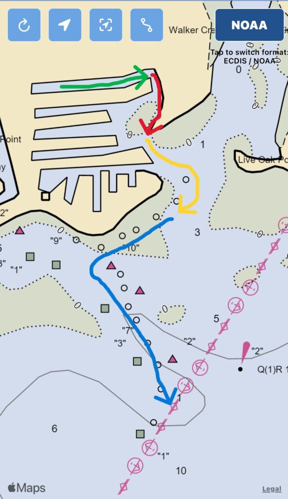
The Figure below provides an overview of each segment using colored arrows. Segment 1 (green) is navigating from ABYC slips in the canal to the infamous Doughnut. Segment 2 (red) is the challenge of threading the needle of the Doughnut to ensure safe passage to Segment 3. Segment 3 (yellow) is a sequence of two bends that have shallows on opposite sides. Segment 4 (blue) is the final stretch off the south beach of Shell Point and into the channel leading directly to the Bay. Segment 4 ends at the tripods, which marks the final marked points in the channel.
The straight navigational line also means hazards are minimal. The person at the helm simply needs to avoid running into the docks on either side and keep a wide enough lane to pass other boats coming and going.
Keep in mind, the canal is a no wake zone! Several people are living on their boats as well, so keeping their experience pleasant is a priority for all users of the canal and channel.
Segment 2: The Doughnut
Navigating around the doughnut, Segment 2, is marked in red for a reason. Most sailors will likely run aground at some point as they navigate in and out. The good news is that this part of the channel has a muddy bottom. Rocks and coral are unusual. At no wake speeds, freeing your boat is pretty easy, even with underpowered outboard motors.
In addition, doughnut circumnavigation really only spans a few hundred feet. The entire journey will take about one minute. Thus, this part of the channel is mercifully short.
The Doughnut creates a narrow passageway barely big enough for two boats to pass.
Unfortunately, this part of the channel is not particularly well marked. The channel is bounded by an above water spit of land on the east side and a series of wood posts on the west side that serve as unmarked channel markers. These wood poles are often the resting place of pelicans and other fowl (see this video).
Boats should at all times stay east of these pilings! For those new to sailing, traveling out of the bay, keep the polls on your right (starboard) side. Sailing to the west (port) side of these polls will inevitably lead to running aground. Assistance from another boat will likely be necessary to pull yourself off the shoal.
Attention to distance from the poles is crucial!
When heading out, attempt to stay within 2-3 feet of the pilings. This is the deepest part of the channel and provides room on the port side for returning boats to pass. (See this video for what the Doughnut looks like leaving toward the bay or entering on the return.)
Traveling past The Doughnut on the way out to Apalachee Bay
If passing through this part of the channel is navigated at no-wake speed, however, running aground will be more of a nudge than a hard grounding. This kind of grounding has an easy fix: put the motor in reverse and ease back into the channel.
Note: Traveling to the Bay from ABYC under sail is not recommended. While southerly and south easterly winds are normal, only the most experienced sailors are likely able to navigate the channel and canals under sail.
The best option while circumnavigating the doughnut is to stay in the middle of the channel.
If another boat is in the channel, one option is to wait until the channel is clear. Since this section of the channel is short, boats typically clear it in just a few minutes.
Pro-tip: Create an imaginary line between the pole at the entrance to the doughnut and the pole at the end. Stay to the port (left) side of this line. If the boat strays or drifts onto this line, or to the right, the boat is likely to run aground.
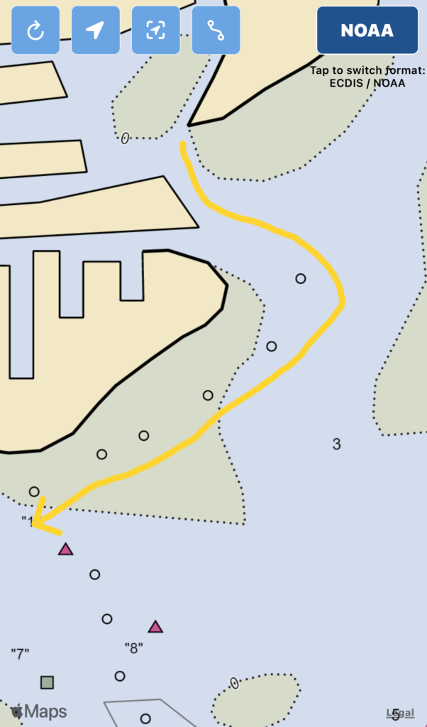
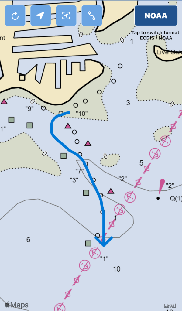
Segment 3: The Big Bends
The doughnut is the most challenging feature of the channel to navigate. But, alas, the next segment in the trip requires its own level of awareness and attention to shallows.
Staying as close to the middle of the channel as possible when you leave the area of the doughnut is the best way to stay clear of these shallows. Fortunately, this part of the channel is pretty wide with plenty of room to pass boats entering and leaving the channel.
Leaving The Doughnut and entering into the main channel toward Apalachee Bay
Nevertheless, the peninsula that is the eastern boundary of the Doughnut has an extensive shoal on its southern side. Even at low tides, this shoal is not often visible. Stay at least 200 feet to the east of this feature. However, straying too far east also has its shallow water hazards on the starboard (right) side. Thus, the middle of the channel continues to be the best navigational route.
Fortunately, once you have journeyed into this part of the channel, formal channel markers are visible and clear. (Going out, red on the left, green on the right. On the return: Red Right Return!)
Stay within these markers at all times. Even a slight drift outside the imaginary lines that link these markers risks running aground.
Pro-tip: On days with some wind, the shallows closest to the west side of the channel usually have calm water.
Once you have made the second turn heading west, your boat should be parallel to Shell Point and Shell Point Beach. This is a straight shot to the main part of the channel, which is Segment Four.
Segment 4: Blue Water
Staying close to the center of the channel in Segment 3 and Segment 4 are the best ways to ensure your boat stays in deep water. Water depths become progressively deeper within the channel markers once the vessel starts to run parallel with the Shell Point peninsula and beach.
Once the boat has reached the beach, steer the boat so that it will turn at a 90 degree angle into the final part of the channel. This is a deep channel but it bisects shoals on both sides. Straying to the channel markers our venturing outside will likely result in grounding the boat.
Follow the shallow in a straight line south until you pass the “tripods” – physical features consisting of three wooden pylons on both sides of the channel. These are about one mile from ABYC Yacht Club.
Congratulations!
You have navigated the canals and channel of Shell Point to the Apalachee Bay!
SR Staley has one more than 11 literary awards for his fiction and nonfiction writing. He is on the full-time faculty of the College and Social Sciences and Public Policy at Florida State University as well as a film critic and research fellow at the Independent Institute in Oakland, California. His award-winning Pirate of Panther Bay series (syppublishing.com) has won awards in historical fiction, mainstream & literary fiction, young adult fiction, and reached the finals in women's fiction. His most recent book is "The Beatles and Economics: Entrepreneurship, Innovation, and the Making of a Cultural Revolution" due out in April 2020 (Routledge).